

Westport Flood Protection Scheme
Reset

Community information evenings
We held community information evenings on 22 and 24 Septembr 2026 in Westport.
They cover off a lot of information about what the consultation is about and the project reset process to arrive at the counsultation options. If you couldn’t make the meeting or would like to go over the content again, you can read or download the full presentation here.
A recording of the meeting held on 22 September 2026 is also available on the WCRC YouTube page.
In 2026, a review of the Westport Flood Protection Scheme (WFPS) has been carried out, after it became clear that there were affordability issues.
The costs of the original scheme are now predicted to reach about $70 million, so the project team has worked on ways to reduce that and still deliver a more credible scheme.
One tool for doing so is to lower the level of protection to Westport to protect against an approximately 1 in 67-year flood (similar to July 2021) – as opposed to the 1 in 100-year previously proposed. The level of freeboard (extra height allowance for uncertainty) would also be reduced from 600mm to 400mm following enhanced computer modelling.
The project reset has financial implications for ratepayers and represents additional debt for West Coast Regional Council (WCRC).
These proposed changes represent a significant variation from what is included in the West Coast Regional Council’s current Long-Term Plan (2024-2034) and what was consulted on with the community in 2021. Therefore, additional consultation is required using a Special Consultative Procedure.
Special Consultative Procedure
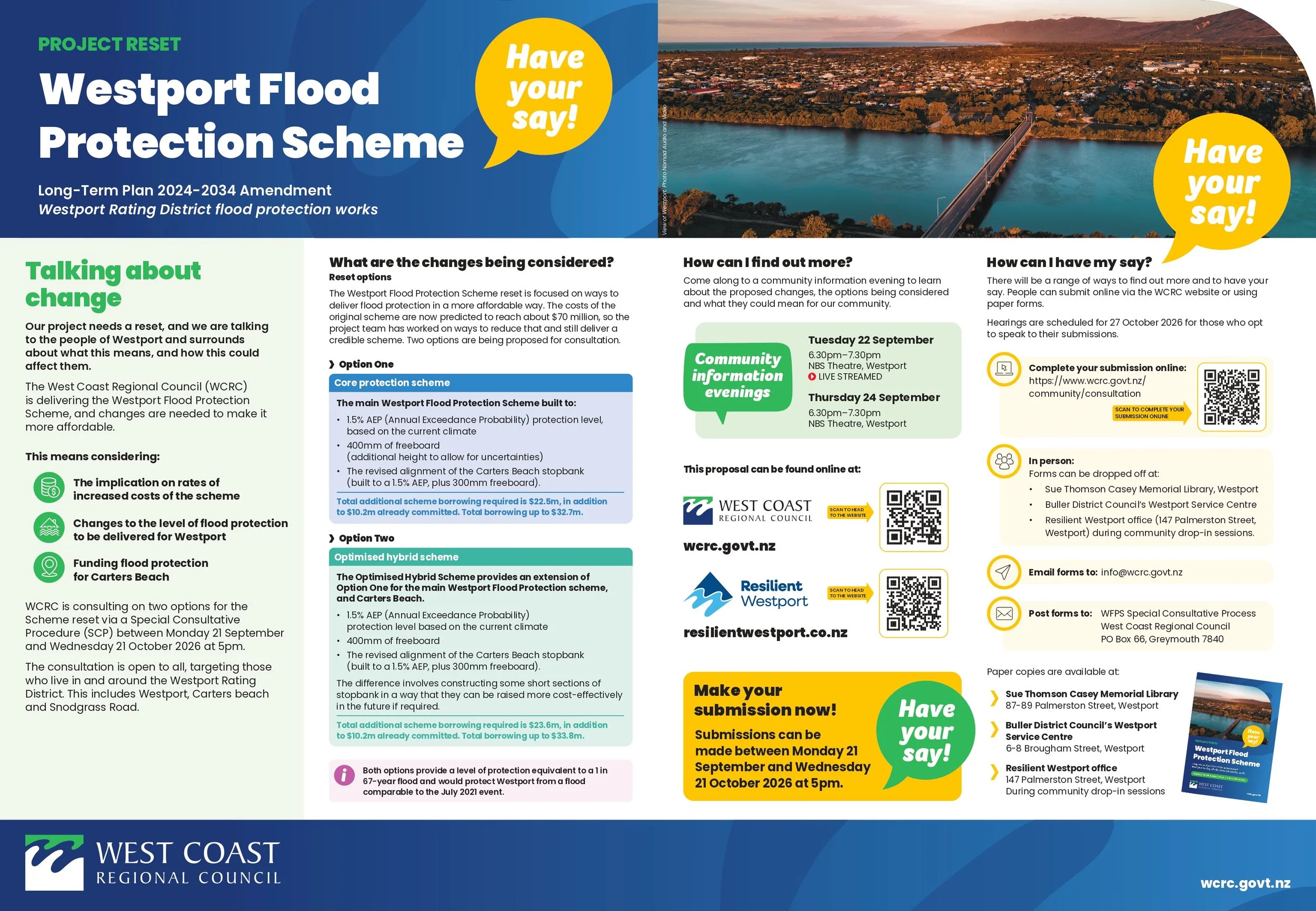
A Special Consultative Procedure on the changes proposed to the Westport Flood Protection Scheme (WFPS) runs from Monday 21 September until 21 October 2026 at 5pm
The Special Consultative Procedure will ask the community to consider two options (below). Another option was considered but deemed too costly.
Option One is the main Westport Flood Protection Scheme (the Core Protection Scheme) built to a 1.5% AEP (Annual Exceedance Probability) protection level, based on the current climate, with 400mm of freeboard (extra contingency height). Plus, the revised alignment of the Carters Beach stopbank built to a 1.5% AEP, and 300mm of freeboard. This level of protection would protect Westport from a comparable flood to the July 2021 event but does not allow for future climate change.
Option Two is an Optimised Hybrid Scheme that builds on Option One for Westport and Carters Beach. It is designed for current climate conditions, with allowance to raise the height of the floodbanks in the future. The additional cost is estimated at about $1 million. The difference is that at select constrained locations, short sections of stopbank would be constructed with a wider footprint that can be cost-effectively built on in the future. For now, they would be built to the same height as Option One and offer the same level of flood protection.
Background:
On 25 August 2026, Regional Councillors approved Council undertaking a Special Consultative Procedure (SCP) on proposed scheme changes and voted to approve the next set of actions to progress the reset of the scheme.
At its 15 September 2026 extraordinary meeting, Regional Council approved the SCP going ahead, subject to auditor’s approval, which was granted on 18 September 2026.
The Special Consultative Procedure on the changes proposed to the Westport Flood Protection Scheme (WFPS) runs from Monday 21 September until 21 October 2026 at 5pm.
You can find out more and provide an online submission on the West Coast Regional Council website: www.wcrc.govt.nz/community/consultation
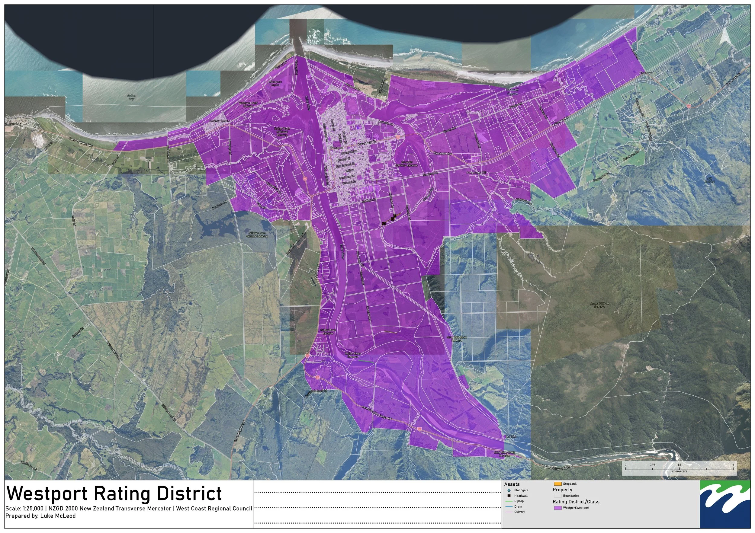
The consultation is open to all, targeting those who live in and around the Westport Rating District (map shown). This includes Westport, Carters Beach and Snodgrass Road.
Cost implications
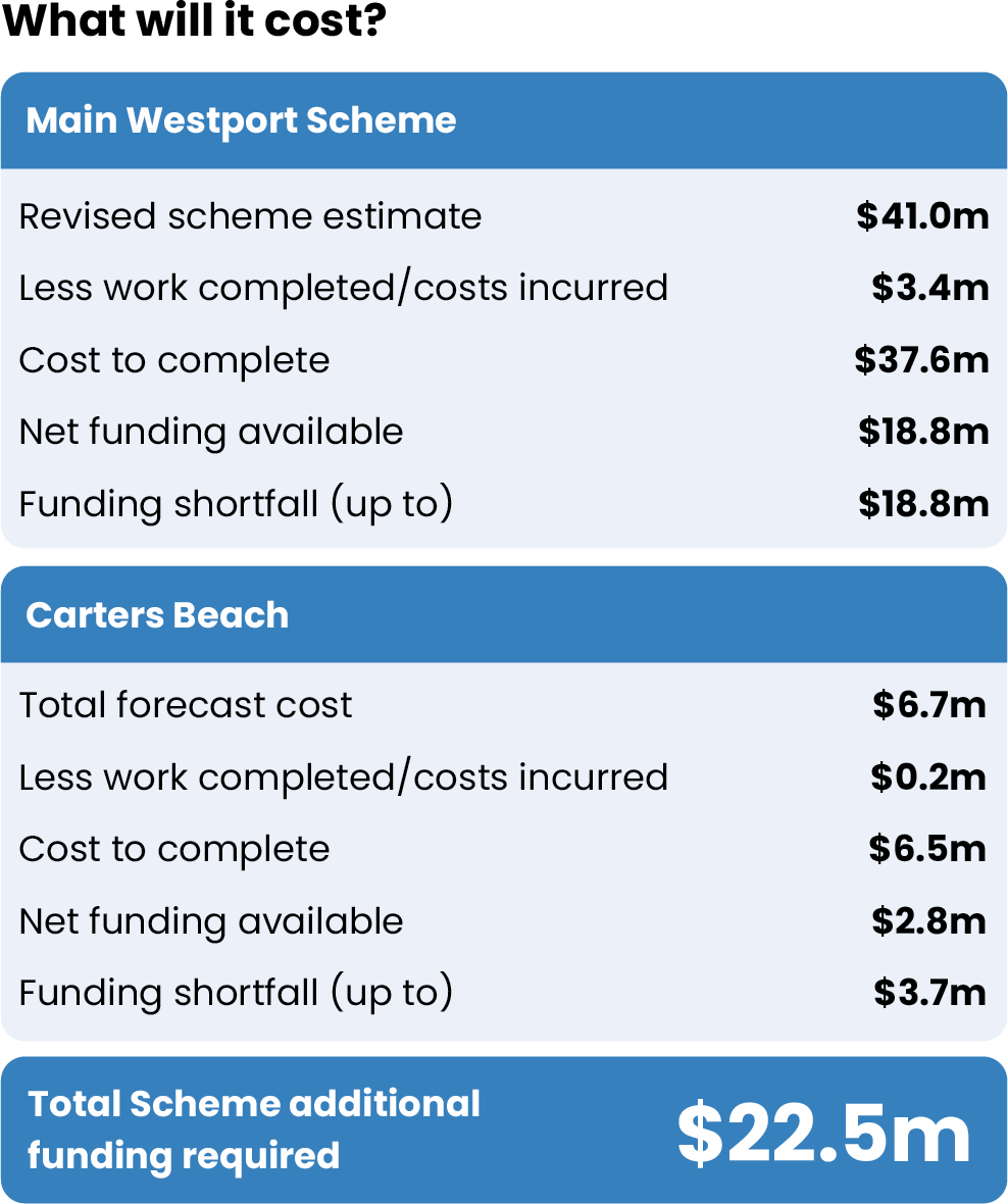
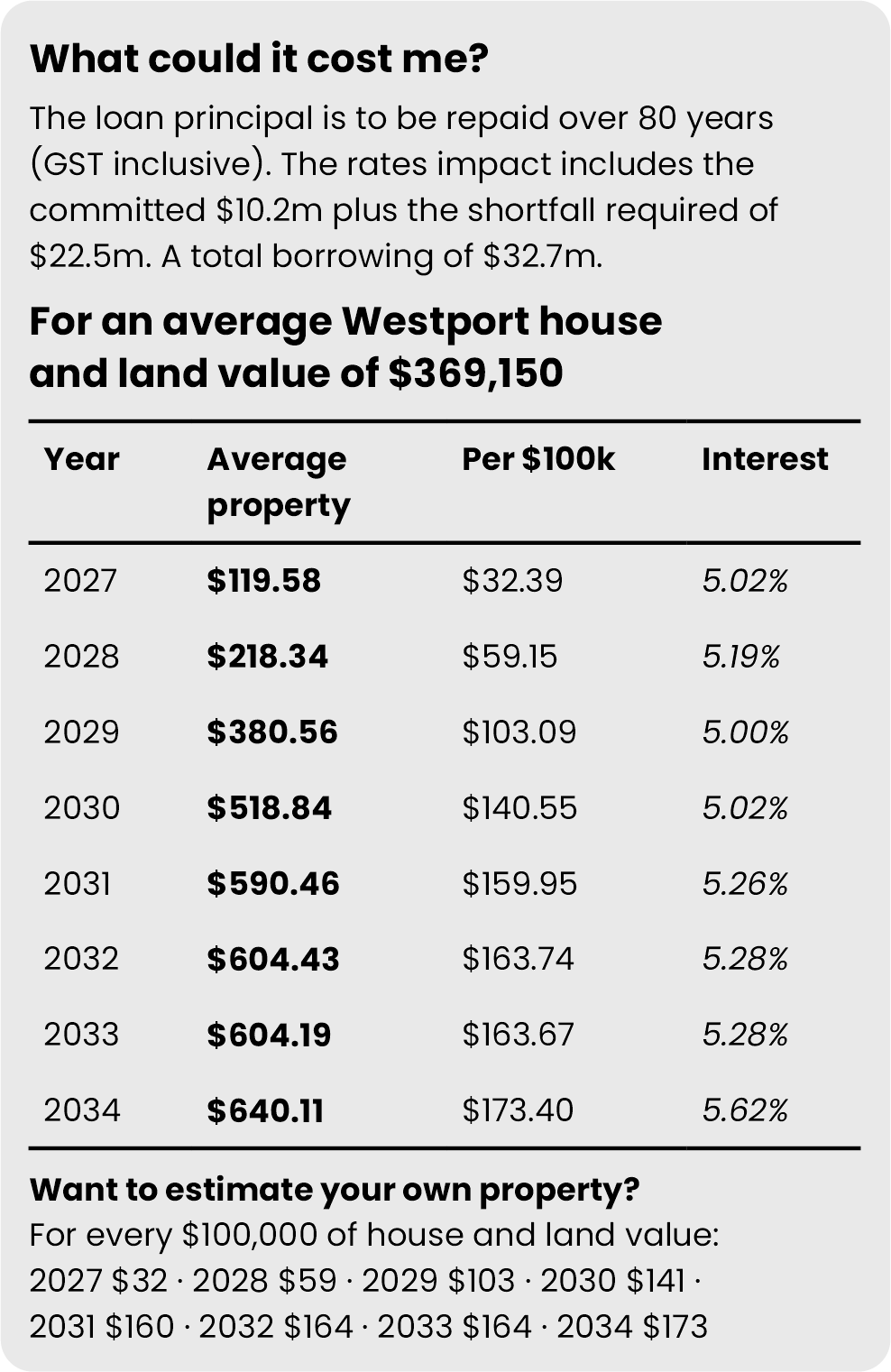
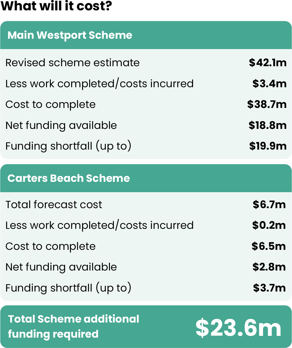
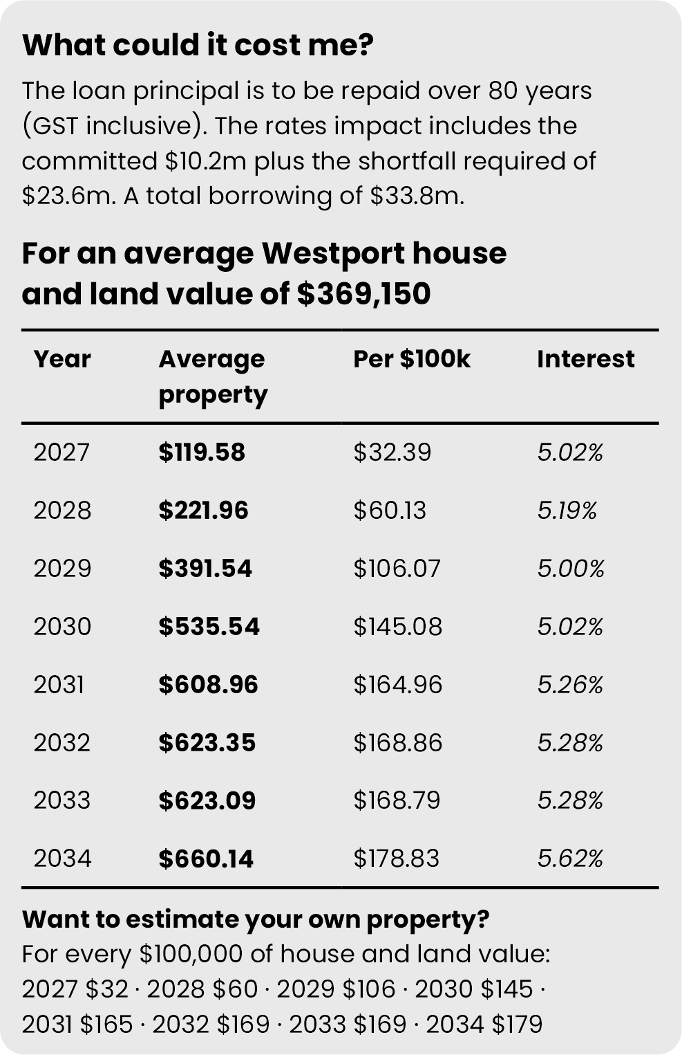
The tables below indicate the costings and rating implications of the proposed options:
Option One
Option Two
Special Consultative Procedure Process
25 August 2026 Extraordinary meeting to approve next steps for Project reset
15 September 2026 Extraordinary meeting to approve SCP
21 September 2026 Special Consultative Procedure scheduled to commence
21 October 2026 Consultation closes 5PM
27 October 2026 Hearings for SCP submissions to be held in Westport
December 2026 WCRC Meeting
To find out more:
You can attend one of our community drop-in sessions on Wednesdays between 11am and 1pm at 147 Palmerston Street, Westport.
You can find out more and provide an online submission on the West Coast Regional Council website: www.wcrc.govt.nz/community/consultation
What is the process once the Special Consultative Procedure is complete?
The results of the consultation will be analysed in October and collated into a report for the West Coast Regional Council.
Public hearings for those who wish to speak to their submissions will be held on 27 October 2026 (11am-3pm approx). They will be held in Westport.
The results of the Special Consultative Procedure will be placed before the full West Coast Regional Council in December 2026.

Your Questions Answered
-
What other option was considered?
Another option was considered in detail but has been set aside based on affordability. This option involved the main flood scheme and Carters Beach being built to the same 1.5% AEP (Annual Exceedance Probability) protection level as Option One and Option Two, but with additional stopbank height to address forecast changes in climate over the next 30 years.
This option would involve stopbanks approximately 0.3 metres higher than the other options but because it cost about $8.8m more than Option One and $7.7m more than Option Two, it was considered too high an additional cost for the community to meet and was set aside as an Other Option considered.
-
The original scheme proposed to provide 1 in 100-year level of flood protection.
The level of freeboard (extra height allowance for uncertainty) was 600mm but this has been reduced due to enhanced computer modelling.
This scheme would now cost around $70m to deliver.
RCP6 was factored into the original design.
-
Why do a Special Consultative Procedure now, rather than wait for the next Long-Term Plan consultation?
There is some urgency around next steps for the WFPS that require a mandate from the community and decision-makers in order to progress. There are significant implications for the community in the revised scheme proposal including additional rate requirements. The community needs to be consulted on these changes before the next major phase of construction gets underway.
Consultation on the Long-term Plan 2027-37 is not due to commence until 2027 and waiting until this time will mean the Project is delayed. Undertaking a Special Consultative Procedure provides the opportunity for the WFPS to make use of the coming summer construction period.
-
A Special Consultative Procedure (SCP) is a highly structured, formal public consultation process governed by the New Zealand Local Government Act 2002.
You may ALSO be interested in:
Media Release: Consultation dates for feedback on the Westport Flood Protection Scheme reset confirmed
Media Release: Regional councillors unanimously agree to the next steps for Westport Flood Protection Scheme reset
Media Release: Regional Councillors to consider next steps for Westport flood protection scheme