
Emergency Management
The Civil Defence Emergency Management (CDEM) component of the Resilient Westport package is focussed on severe flood events. The package includes $500,000 to improve local civil defence capabilities.
West Coast Emergency Management (WCEM) is working alongside Resilient Westport to deliver the programme.
They’re focussing on enhanced evacuation planning and improving arrangements that support evacuation activities. This includes:
reviewing digital systems for data management and sharing
additions to the pool of emergency management equipment and welfare resources
coordinated planning among critical infrastructure agencies and emergency services
community capability and resilience.
Westport Flood Evacuation Response Plan
The Westport Flood: Evacuation Response Plan, focuses on improving arrangements that support flood-related evacuation activities in and around Westport.
The Plan was developed throughout 2025 in conjunction with key stakeholders. It is essentially a plan for Civil Defence Emergency Management (CDEM) Controllers, Emergency Operations Centre (EOC) staff and stakeholders directly involved in carrying out a flood-related evacuation of Westport and surrounding areas such as Carters Beach and Snodgrass Road.
Our focus now is on helping Westport residents understand their part in planning for and taking part in an evacuation - should it be required.
Read more on our Westport Flood Evacuation Plan page.
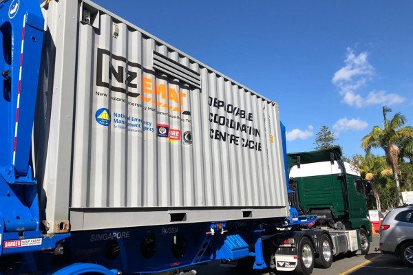
New emergency caches
Two new containerised resources like the caches shown here have been procured by Resilient Westport.
They will be used as possible alternate Emergency Operations Centres (EOC). Each costs about $30,000 and are equipped with essential supplies, equipment and communications tools that are crucial during emergencies.
Four containers were received by the West Coast CDEM group in June 2025.
The two that were funded for Westport by Resilient Westport are a Welfare Cache and resources for an Emergency Operations Centre (EOC).
Welfare caches contain the equipment to support the delivery of welfare services to people at a Civil Defence Centre or their homes.
EOC Pods contain the equipment required to establish an off-site Emergency Operations Centre and to support the deployment of volunteers.
In the case of an emergency, they can be transported to where they are needed.

Business Continuity
Supporting Westport businesses through a flooding (and other) emergency is a key goal for local Emergency Management.
In the same way that we are encouraging members of the community to think about being prepared, we know local businesses need to do the same.
Our campaign in 2025 aimed to encourage and support local business owners, managers, and entrepreneurs to take simple actions today, to prepare for flooding and other emergency situations tomorrow.
We had a great response to our free workhops and we still have some amazing resources for people to tap into to carry on that momentum.
It is never too late to plan ahead.
Read more on our Business Continuity page
Planning saves lives
-
Frequently Asked Questions Emergency Management Survey (October 2025)
How long does the survey run?
The survey will run from 17 October until 4.30pm on Friday 7 November 2025.
How can I fill out the survey?
The survey can be filled out online on this page: letstalk.bullerdc.govt.nz/emergency-management-survey
Paper surveys and information can be found at the Buller District Council Westport service centre or the Sue Thomson Casey Memorial Library in Westport.
Is the survey anonymous?
We ask that you supply your name and email address or phone number to help ensure the source and accuracy of the survey responses we receive. Any sharing or publication of survey results, including with local Civil Defence Emergency Management, will be in an anonymised format.
How will the survey results be of use?
We are preparing an enhanced flood evacuation plan for Westport, Carters Beach and Snodgrass Road.
The planning we’ve done to date is based on good information about our community’s capabilities and preparedness such as Census data and statistical information about the population, households and local tourism. But we need the help of our local residents to confirm the reliability of this information and improve our knowledge on the extent the community is able to self-evacuate if a major flood warning confirms an evacuation is necessary because of serious safety risks.
The plan will be a living document so new information will be considered and incorporated into it as we go along.
When will the enhanced evacuation plan be made public?
We will share more information about the plan with the community later in the year. It is important to us that people in the community know who is doing what in an emergency and what they can do to be better prepared.
What’s the aim of the Plan for the community?
We want to ensure a high level of awareness among Westport residents in the flood risk areas about the plan and that they know:
how they should prepare (have their own plan)
where to get key information (eg, river levels and what they mean)
how evacuation recommendations or directions will be delivered (channels),
and understand what they should do if an evacuation is recommended or directed.
Who is the Plan for in the emergency response sector?
It is a plan for CDEM Controllers, Emergency Operations Centre (EOC) staff and stakeholders directly involved in carrying out a flood-related evacuation of Westport and surrounding areas such as Carters Beach and Snodgrass Road.
Who can participate in the survey?
The survey is intended for residents of Westport, Carters Beach and Snodgrass Road who are aged 18 and over. We only need one response for each household.
How will people know when to evacuate?
There would be wide-spread messaging if an emergency flood evacuation were required. Sources of information will include radio, television, social media, websites, mobile public announcement systems and, at the most appropriate time, an emergency mobile alert. Door knocking may occur if other communication methods are not available.
What are the flood evacuation triggers?
Deciding on an evacuation is a complex matter involving the consideration of many things including severe weather warnings (red or orange heavy rainfall warnings from MetService), cumulative rainfall, field measurements and observations (including from river and rain gauges), and geotechnical and structural performance monitoring, satellite imagery, rain radar (if available), and expert opinions.
A key factor for Westport is ensuring people can get across the bridges from the main township to places of safety in advance of a major flood. In all cases, avoiding or reducing serious risk to human life is a primary concern.
Other important contextual considerations for an evacuation decision may include: adverse weather conditions reducing effectiveness of emergency resources, road or bridge closures, relatively large numbers of people at risk (eg, peak tourist season or visitors attending an event), and time of day – the evacuation process will be much safer if it can start and be completed during daylight hours.
Would there be advance notice of an evacuation to give people time to prepare in a flooding emergency?
Severe weather warnings, cumulative rainfall data and river and rain gauges – among other tools –provide good information to help predict a major flooding event. We anticipate 12 or more hours’ notice, but this will depend on the circumstances at the time.
Is the survey only for flood-related evacuations?
The Plan we are working on is focussed on flooding, but the learnings from this process will apply to most, if not all, other emergency situations. Improved planning and preparedness help in all emergency circumstances.
How can I find out more?
Copies of these FAQs and paper survey forms will be placed at the Buller District Council Westport service centre or the Sue Thomson Casey Memorial Library in Westport.
Residents can also drop into the regular Tuesday Resilient Westport community drop-in sessions from 12noon to 2pm at 147 Palmerston Street.
-
We already have Civil Defence in Buller that is managed through West Coast Emergency Management Group (WCEM).
All four councils on the West Coast and iwi, make up the WCEM Group.
West Coast Regional Council
Buller District Council
Grey District Council
Westland District Council
Te Rūnanga o Makaawhio
Te Rūnanga of Ngāti Waewae.
The aim of the WCEM is to coordinate emergency management activities, mainly focussed on readiness and response.
As we saw in the flood events of 2021 and 2022 (and many other occasions), in an emergency WCEM sets up an Emergency Operations Centre (EOC) to oversee the coordination of agencies and communities involved in a response.
The operational direction of WCEM is provided by the four councils, Fire Emergency NZ, Police, Health NZ, Medical Officer of Health, St John, the Group Controller, Department of Conservation, Makaawhio and Ngāti Waewae. These agencies meet on a quarterly basis and make up the ‘Coordinating Executive Group’ (CEG).

