About Resilient Westport

The Resilient Westport programme is funded with $22.9m from central government to support initiatives that will improve Westport’s flood resilience.
Resilient Westport began operating in earnest in early 2024.
Both the West Coast Regional Council (WCRC) and Buller District Council (BDC) play a key role in, and have specific responsibilities towards enabling the Resilient Westport Package.
Resilient Westport was initially overseen and governed by the Resilient Westport Steering Group. In late 2025, it was decided the various elements of the programme of work would be overseen by the relevant entity that was delivering them, shifting governance to council-level. Therefore, the Westport Rating District Joint Committee, the West Coast Emergency Management Joint Committee and Buller District Council have taken over the oversight previously provided by Steering Group.
Background:
The Resilient Westport Steering Group was appointed by Ministers in 2023 to oversee and synchronise the various packages of work from funding agreed in the budget (find out more below).
The Resilient Westport Package came about after a business case for co-investment in Westport’s resilience was made to government by WCRC, BDC, and Te Rūnanga o Ngāti Waewae.
This followed the floods of July 2021 and February 2022.

Who IS doing the work?
The Buller District Council (BDC) and West Coast Regional Council (WCRC) are working collaboratively with iwi, other organisations and Government departments to deliver projects approved within the Resilient Westport package.
This centres around protecting Westport where possible, improving emergency management capability and planning for low risk growth areas.
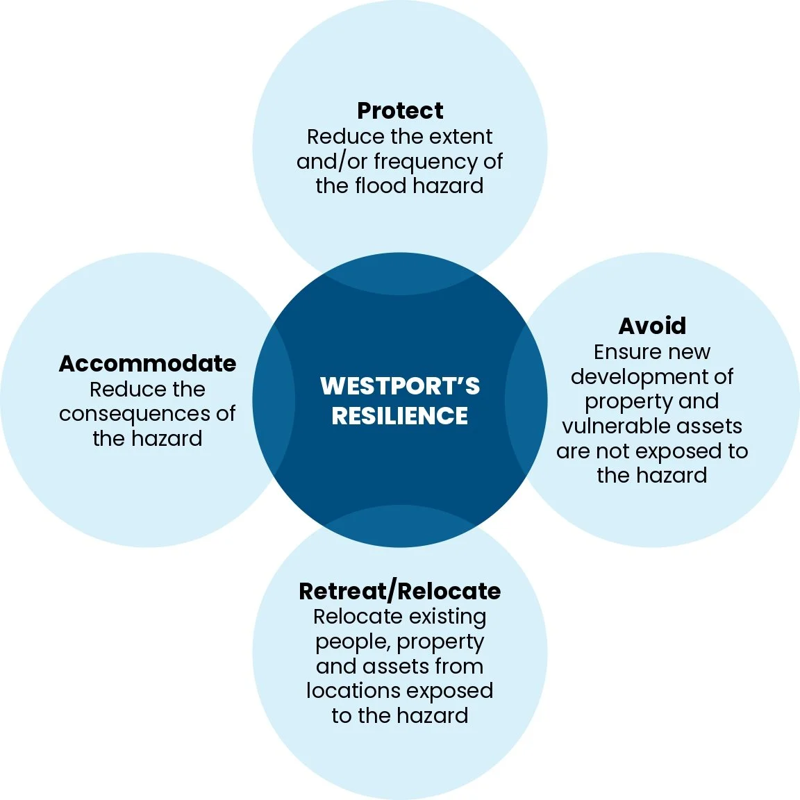
The various packages of work will be delivered by the respective Councils based on the PARA (Protect, Avoid, Retreat, Accommodate) framework (explained further below).
Key areas of BDC responsibility fall within the Avoid, Retreat, Accommodate functions. This includes the Master Planning process, along with other works such as stormwater improvements and the essential infrastructure repairs programme carried out under Buller Flood Recovery.
West Coast Regional Council’s focus is largely on Protect measures with the responsibility for designing and implementing flood protection measures such as the Westport stopbanks and floodwalls.
The Resilient Westport office is at 147 Palmerston Street, Westport. It is a site office for staff working on the Resilient Westport programme. The front area is open on Tuesdays between 11am and 1pm for people to drop in and find out more about the project.
As the project is Government funded, along with local share, representatives from the Department of Internal Affairs (DIA) and National Emergency Management Agency (NEMA) are involved.

How is the government’s $22.9m contribution being applied?
The funded packages of work that the Resilient Westport Steering Group oversees and co-ordinates include:
$15.6m for floodwalls and stopbanks to reduce the risk of flooding, this is in addition to the Westport Rating District’s contribution. Further work is being undertaken to determine the detailed location and design of the flood mitigation works. An additional $300,000 is allocated to the technical review of the preliminary floodwall designs and project costs.
$1.5m for the land transfer and reafforestation of the Organs Island area (with any unallocated funds going to contingency).
$1.0m in contingency (although further cost increases must be met by Councils).
$1.0m to replenish the Regional Council’s emergency fund (paid by DIA).
$0.75m for a development plan for the Alma Road area and to support the development of other low-risk areas (Master Planning).
An Adaptation Relief Fund of $2m to assist homeowners still exposed to risk after the implementation of flood mitigation measures.
$0.5m to improve local civil defence capability.
$0.25m for a sea level monitor/tide gauge to improve the early warning system.
The main project that makes up the Resilient Westport package of work is physical flood protection.
Other initiatives include Master Planning, emergency management, Adaptation Relief Fund, Organs Island, and improving flood warning systems.
Key Projects
-

Flood Protection (floodwalls)
Flood protection involves building floodwalls/stopbanks to protect parts of Westport in the event of future flooding events.
Led by West Coast Regional Council, it is the largest of the Resilient Westport projects with a contribution of $15.6m from central government, in addition to the Westport Rating District’s contribution.
-

Master Planning
Master Planning is a strategic planning exercise that looks to provide options and opportunities for the short, medium and long term future of the greater Westport area.
The Master Planning process seeks to provide a holistic road map for the community, public and private sector and guides the development of areas of land for future use, creating greater choice for the community around lower-risk areas.
The background and early vision were completed in late 2023. The focus in 2024 was the planning process and stakeholder engagement. Between April and December Isthmus and Resilient Westport ran regular targeted stakeholder ‘Design Weeks’ with over 150 local community members being invited to a series of interactive and iterative workshops. The wider community was invited to share their thoughts on the Draft Master Plan in February/March 2025.
The Plan was endorsed by Buller District Council in March 2025. The next stage, implementation, is being overseen by Buller District Council.
-

Organs Island
Organs Island is part of a historic flood overflow from the Buller River to the Orowaiti River.
In July 2021, it overflowed into the Orowaiti Estuary, reaching parts of Westport. Revegetating the area can trap water and sediment, slowing floodwaters and raising the land over time through self-seeding.
The transfer of ownership of Organs Island from LINZ to DOC and to vest Organs Island as a local purpose (flood protection) reserve for West Coast Regional Council (WCRC) to manage as an administering body was completed in February 2026.
WCRC has now taken over the management of the land. A flood protection options report is being prepared to understand the requirements and costs. Council will then consider the plan for Organs Island.
See the latest Media Release.
-

Adaptation Relief Fund
An Adaptation Relief Fund of $2m has been allowed for to assist home owners still exposed to risk after the implementation of flood mitigation measures.
Buller District Council and West Coast Regional Council are working with Government on the criteria and implementation of the Adaptation Relief Fund.
________________
In late 2025, the administration of the $2 million Adaptation Relief Fund moved from BDC to WCRC. This happened as most of the talking to affected parties falls on the Regional Council as it is building the stopbanks. It makes sense for them to consider parties who are outside the main scheme (i.e not protected by the stopbanks) at the same time. These conversations will already be taking place as part of the Resource Consenting process.
-
West Coast Emergency Management
Civil Defence Emergency Management focuses on accommodating severe weather events. The Resilient Westport package includes $500,000 to improve local civil defence capabilities.
The work is guided by West Coast Emergency Management (WCEM) alongside the Resilient Westport Programme team.
Other enhancements being worked on involve better evacuation procedures, upgraded digital systems for data sharing using GIS platforms, coordinated planning among critical infrastructure agencies and emergency services, and community engagement.
Read more on the Emergency Management page on our website.
-

Sofar Spotter Ocean Wave Buoy
Led by WCRC and the Westport Harbour team, the Sofar Spotter Ocean wave buoy was placed offshore from Westport on June 7, 2024. The programme has allocated $250,000 for the buoy to enhance early warning systems. It collects real-time data on wave period, height, direction, wind speed, sea temperature, and barometric pressure. This data will update the NIWA flood model for Westport, improving the accuracy of flood inundation maps by providing local conditions instead of national-scale datasets. The data will be available on the Buller District Council and West Coast Regional Council websites.
Unfortunately, the wave buoy was damaged in a storm in 2024 and was subsequently replaced. In September 2025, the replacement buoy was also ripped from its moorings in a storm. It was recovered a few weeks later but is yet to be reinstated.
In addition to the wave buoy, Resilient Westport has funded two new radar water level recorders - for the Orowaiti Bridge and one on the Buller River at SH67. They were installed by WCRC and will provide river level and flow information that can be used to further update the flood model for Westport. A third water level monitor is planned for the Buller River upstream.
Read more about the wave buoy here
-
The Resilient Westport Steering Group was appointed by Ministers in 2023 to oversee and synchronise the various packages of work that will be delivered by the respective Councils from funding agreed in the budget.
The Steering Group was independently chaired and comprised key leaders from Buller District Council, the West Coast Regional Council, Te Rūnanga o Ngāti Waewae, the Department of Internal Affairs and the National Emergency Management Agency.
The Steering Group was made up of:
- An Independent Chair, the Chair and Deputy Chair of the West Coast Regional Council (WCRC), the Mayor and Deputy Mayor of Buller District Council (BDC), the CEOs of WCRC and BDC, a representative of the Department of Internal Affairs (DIA) and National Emergency Management Agency (NEMA).
The group met for the last time in late 2025.
You can see the Terms of Reference and minutes of meetings on the West Coast Regional Council website.
The Steering Group was not held in a public forum as it often covered sensitive detail around elements of the programme as well as commercially sensitive costings, and at times private information relating to residents that may be affected by the proposed structural protection.
As of late 2025, it was decided the various elements of the programme of work would be overseen by the relevant entity that was delivering them, i.e locally governed. Therefore the Westport Rating District Joint Committee, the West Coast Emergency Management Joint Committee and Buller District Council have taken over the oversight previously provided by Steering Group.
-
-
The Resilient Westport Package works under the PARA (Protect, Avoid, Retreat, Accommodate) framework for adaptation.
Protect: to identify preferred flood risk mitigation structural and nature-based protection options.
Protect actions can include sea walls, floodwalls, dykes, scour protection, dune building and beach nourishment.
In the Westport context, the aim is to protect areas in the short term where practical and affordable. Protect does not mean eliminating the risk of flooding; it means reducing the risk of flooding as much as possible.
Avoid, Retreat and Accommodate: all look at how future growth can be planned to mitigate the risks of further flooding.
Avoid actions can include: restrictions on building/future developments, zoning, land acquisition, or transfer of development rights. It also includes avoiding development and intensification in high-risk areas as quickly as possible.
Retreat actions can include: easements, land acquisition, and wetland restoration. This can include relocating at-risk communities in the medium and long term into low-risk areas.
Accommodate actions can include: flood construction levels (floor heights), wet flood proofing, elevated homes, temporary/moveable flood barriers and flood storage areas to accommodate flooding in some areas.
-
Westport was hit by severe flooding in July 2021 and again in February 2022. It is likely to face increasing flood events in future and currently has limited flood protection in place.
The Resilient Westport Package came about after a business case (Kawatiri Business Case) for co-investment in Westport’s resilience was made to government by the West Coast Regional Council, Buller District Council, and Te Rūnanga o Ngāti Waewae.
In Budget 2023, the Government set aside $22.9 million for a number of flood resilience initiatives. This commitment has been reaffirmed in April 2024 by the National-led coalition government.
How did the floods impact Westport and beyond?
In July 2021, heavy rainfall caused severe flooding in Westport and surrounding areas, causing widespread damage to properties and infrastructure, interrupting people’s lives, and shaking up the community.
The flow breached Westport’s existing flood defences, with 826 properties and over 2,000 people requiring evacuation. Three separate civil defence centres were established to support displaced people in need of emergency accommodation. Out of 983 dwellings in Westport town, 23% of the housing stock needed repairs to become habitable.
Further severe flooding occurred district-wide in February 2022. This was a combination of two consecutive weather events and caused significant damage to Westport’s infrastructure, and many farms and other areas of Buller.
During the first event (1-4 February 2022), a red weather warning was issued, and a State of Local Emergency declared. 119 people were evacuated in total. Widespread local flooding occurred, many roads were closed, and some properties were inundated.
The second February weather event of 9-10 February 2022 was given a Met Service ‘orange’ designation. The EOC was reactivated with a State of Local Emergency being declared on 10 February 2022. The Karamea Highway was badly affected, and farms flooded with the Maruia and Inangahua rivers in peak flows. All roads north and south of Westport were closed effectively cutting off the district. Further mandatory evacuations within Westport occurred.
This second February flood event caused extensive infrastructure damage across the district. You can read about the infrastructure repairs that followed from these events on the Buller Flood Recovery website.
Buller Flood Recovery was set up to help with the immediate response and subsequent recovery between August 2021 and January 2023. The Buller Flood Recovery website has been taken down but Resilient Westport holds records of the work carried out by the Flood Recovery team.