
Lower orowaiti

The Lower Orowaiti stopbank dimensions:
Length: 2,980m
Average height: 1.6m
Width at base: around 17m
Width at crest: 4m
Mainly earthen stopbank but a combination of stopbanking may be used.
Construction: Avery’s - starting January 2027.
Balance of work: construction is likely to take place from 2027 onward (subject to consenting).
Lower Orowaiti is one of five main sections of stopbanks that make up the scheme:
Lower Orowaiti, Upper Orowaiti, North End, Lower Buller (Wharf to Buller Bridge) and Upper Buller (SH67 from Buller Bridge to Nine Mile Road).
Lower Orowaiti covers the area in Westport between Craddock Drive and Eastons Road to where it meets Stephen Road.
The Lower Orowaiti section covers the area in Westport between Craddock Drive and Stephen Road.
The stopbanks planned for there aim to protect homes from overflow from the Orowaiti River and estuary.
This section is made up of:
Avery’s stopbank
Eastons Road SH67 to Stephen Road
and Craddock Drive to Avery’s stopbank.

Avery’s stopbank
Indicative map of the Avery’s stopbank
More information on Avery’s
Under the Te Tai o Poutini Plan (TTPP), both BDC and WCRC are required to consent the stopbanks for the Westport Flood Protection Scheme.
The consenting process took longer than hoped due its complexity and managing the potential implications of the stopbank on nearby properties.
Rosco Contractors Ltd has been awarded the tender to construct the stopbank and install the culverts, being supplied by Humes.
A major culvert requires replacing as part of the work, as well as some smaller culverts. Culvert pipes have been pre-purchased. The team has worked closely with Buller District Council over this part of the process.
When construction gets underway, it is expected to involve temporary road closures on Orowaiti Road to allow for safe installation of the culvert and construction of the stopbank. Traffic management plans will be in place and communicated in advance to minimise disruption.
In August 2025, some trees were removed along Orowaiti Road to prepare the space for the stopbank once construction gets underway. This preparation will also facilitate the advancement of the remaining areas of the Lower Orowaiti stopbank along Orowaiti Road.
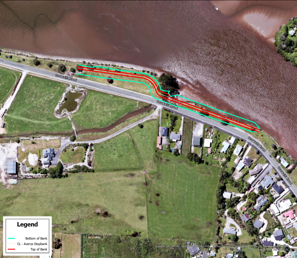
The Avery’s stopbank is part of the Lower Orowaiti section.
The stopbank length will be about 340 metres. This is revised from 540 metres earlier indicated, due to the revision of plans.
Construction on Avery’s stopbank is expected to take about four months.
Height between 1.1 and 1.5 metres high.
Travels over a large culvert where height will reach 1.7m
Width between 15 and 20 metres wide at the base.
What you need to know about the Avery’s stopbank
Resource Consent has been granted Resource Consent by the West Coast Regional Council (WCRC) and Buller District Council (BDC) as at June 2026.
Work on building the Avery’s stopbank in Westport is likely to start in January 2027.
This is the first window where the work, once started, can be completed all in one go.
The constraints of the Resource Consent relate to the Orowaiti Lagoon area being protected as a Coastal Marine Area. The consent conditions protect native fish and migratory birdlife at their most sensitive times of year. Work on the culvert and tidal gate can't take place during the whitebait migration season between September and October, and works in the Lagoon are limited over the spring and summer months when birds such as bar-tailed godwits and banded dotterels are present.
If work could be started earlier, it would need to stop again over September and October, early summer and then Xmas before re-starting in January. This approach will allow the team to build the stopbank and the culvert all at once and will pose the least inconvenience to whitebaiters and neighbouring properties on Orowaiti Road.
Once an exact start date is locked in, residents in the nearby area will be given at least two weeks’ notice of any work happening in their vicinity.
You can read the full media release on the start date here.
The Avery’s stopbank will provide protection to 30 to 40 properties in the Orowaiti Road area, which are at risk of overflow from the estuary.

What about the balance of the Lower Orowaiti section?
The balance of the section is still in the investigation and design phase. Consent planning is underway.
You may ALSO be interested in:
Media Release: Start date signalled for Avery’s stopbank
Media Release: Resource Consent granted for Avery’s stopbank in Westport
Media Release: Consent application lodged for Averys stopbank
Notice: Tree removal for Averys stopbank
Media Release: Drill rig to be spotted around Westport
Media Release: Work on McKenna stopbank wraps up
Media Release: Ceremony to mark the breaking of ground on Mckenna stopbank
Media Release: Work to start on Floating Lagoon vegetation clearance
Media Release: Start of Cats Creek work marks important milestone