
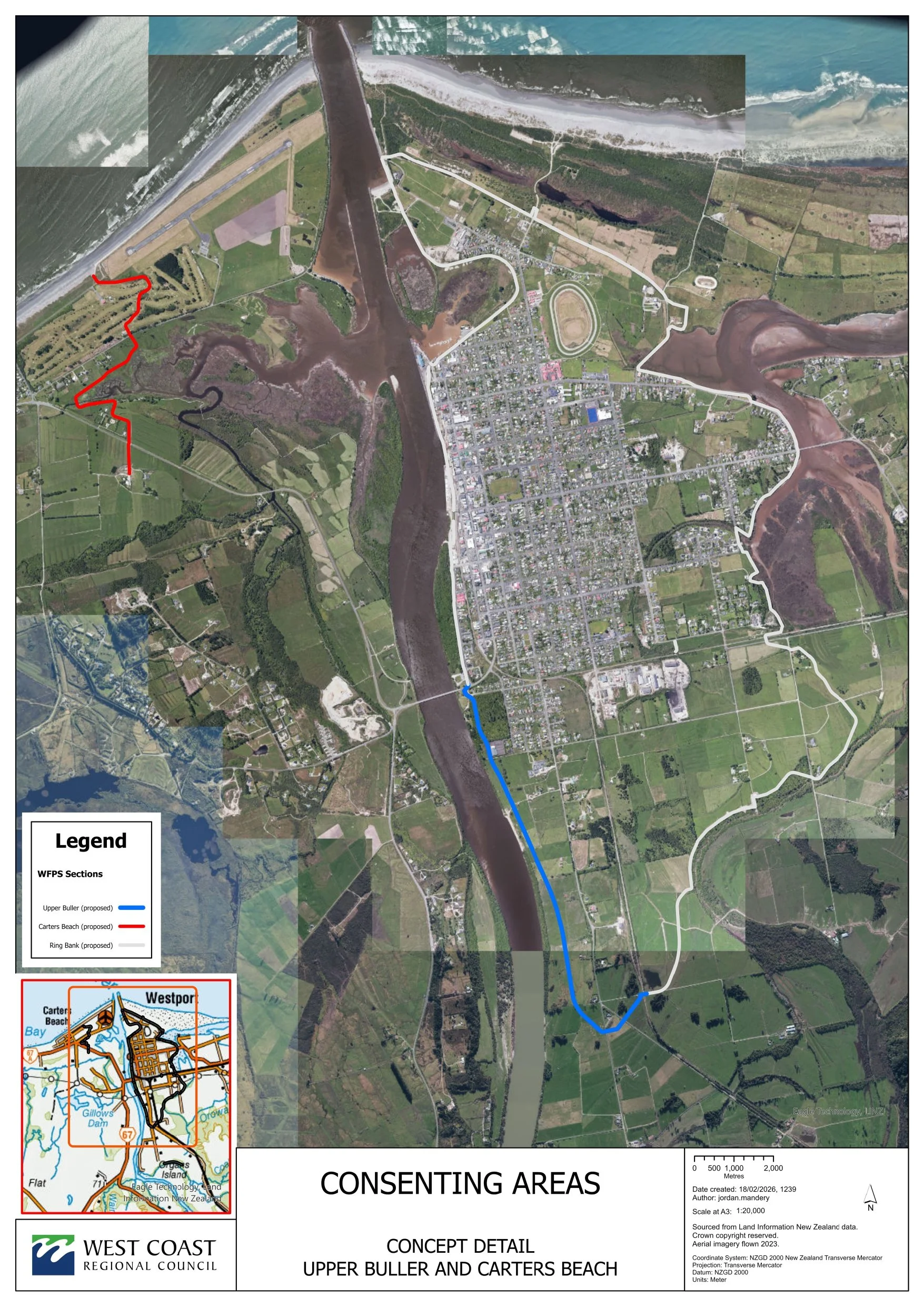
Carters Beach

The main scheme is divided into five main sections of stopbanks:
Lower Orowaiti, Upper Orowaiti, North End, Lower Buller (Wharf to Buller Bridge) and Upper Buller (SH67 from Buller Bridge to Nine Mile Road). In addition, stopbanks are planned for Carters Beach and Snodgrass Road.
Carters Beach and Snodgrass Road are not covered by the Resilient Westport government funding, so this work is likely to come from local share (WCRC) and pledged donations.
A group of local businesses have recently pledged over $2m towards flood mitigation works for Snodgrass Road and Carters Beach.
Carters Beach
The proposed Carters Beach stopbank will be an earthen structure approximately 2.4kms long.
Completed: preliminary design, river modelling, site investigation and geotechnical reporting, initial design and review, Assessment of Environmental Effects, detailed design, Resource Consent application lodged (February 2026).
Current status: A combined Resource Consent Application for the Carters Beach and Upper Buller stopbanks was lodged on 20 February 2026.
Affected parties, including landowners/occupiers, where the proposed flood walls are planned to cross their property or near to it, will be contacted to discuss the proposed work.
Early engagement with affected landowners has been carried out and a meeting with the Carters Beach community was held in August 2025. The aim of the meeting was to share the stopbank location, size and timing and connect with affected residents.
Affected parties include local iwi, landowners and the Westport Golf Club. Where possible, adjustments have been made to the alignment to better suit affected parties. Geotech investigations were carried out in late 2025 to help map out the below ground landscape to inform the final design and construction.
Consenting
The completed Upper Buller stopbank (up-river from the Buller Bridge) will unfortunately increase the flooding risk for Carters Beach, on the opposite bank downstream. Upper Buller is part of the ring protection to help protect the Westport township from severe flooding.
The planned work aims to protect Carters Beach from this and mitigate the current flood risk for Carters Beach from major floods.
Because the Upper Buller and Carters Beach situations are interdependent, a combined Resource Consent Application was lodged. We contracted senior staff from WSP to work on this combined strategy.
Estimated construction dates: Starting late 2026 (subject to funding and consenting).
Once consent is granted, there will be a tendering process for the work.
The Carters Beach stopbank will be 2.4 kilometres long and will take about six months to build.
Read the latest Media Release here.

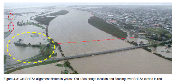
Note, WCRC may remove the old SH67A road alignment as part of the proposed activity.
This is circled yellow in Figure 4-3 (below). This road alignment is associated with an 1888 bridge which has been removed and is now redundant. This is included as an option as removing the old approaches could reduce the flood level at the Buller River.
-
You can read more about what was presented to the residents of Carters Beach on the planned stopbank for their area via the link below:
-
Resilient Westport/West Coast Regional Council Carters Beach Frequently Asked Questions (July/August 2025)
Why is a stopbank being proposed for Carters Beach?
A stopbank for Carters Beach is being planned because, once new stopbanks are built around Westport, the flood risk for Carters Beach will be slightly higher during major flooding events.
The proposed stopbank at Upper Buller (up-river from the Bridge) will mitigate the flood risk to Westport township, but unfortunately, this increases the flood risk for Carters Beach on the opposite bank downstream.
The West Coast Regional Council is committed to reducing that risk as much as possible.
What level of protection will the stopbank provide?
The stopbank is designed to protect in up to a 1 in 100 year flood, or a 1% AEP.
Technically speaking, the design standard is at 1% AEP with climate change under RCP 6.0 (NIWA advice) and 300mm freeboard. A 1% AEP flood has a 1 in 100 chance of occurring in any given year.
Freeboard is an engineering provision for estimate accuracy and other factors not included (waves, aggradation, debris etc).
How high will the planned stopbank be?
We're still working through the final design, but it's likely that the height will range between 2.5 to 3.3 metres, depending on the location, with gently sloping sides. The width at the base will be around 20 to 24 metres.What will the stopbank look like or be made from?
The stopbank will be an earthen structure approximately around 2.4kms long. As the Carters Beach stopbank is likely to be founded on sand, it may have to be designed slightly differently to other stopbanks to account for this. The results of the geotechnical investigations will be factored into the final design.
Will all the Carters Beach homes be protected from flooding from the Buller River?
Most households will be protected, but it is not possible to mitigate flood risk to five houses upstream of Carters Beach. A sixth can be bunded.
There is still a vulnerability for the community to coastal storm surge crossing the dunes.
What if there is a stopbank on or very near to my land?
If a stopbank is to be built on or near your land, we will have made contact to discuss details, impacts, and next steps.
We will ask for permission to go onto your property, firstly for geotechnical and environmental investigations. Our engineers need to understand the local ground conditions. This requires temporary investigations such as soil testing and shallow drilling. These investigations are short-term, low-impact, and do not involve any permanent changes.
Once there is a final design, a resource consent application will be made. Land access will be finalised.
You will be kept informed along the way and will be well aware before we start construction.
What are the other factors that have been considered in this work?
We have looked at a range of options to mitigate flood risk for Carters Beach. This has taken time and has been complex. The option that has been presented is considered optimal. It is the most cost-effective and protects as many properties as possible.
In getting to this point, we have modelled the impacts of increased river water from the Upper Buller stopbank on the SH67 Bridge. That has been assessed as small.
We have also looked at the implications of the stopbank on SH67A from Westport to Carters Beach to make sure transport links aren’t compromised. We have come up with possible mitigation options and had a positive response so far from NZTA Waka Kotahi.
Will the planned alignment change?
The alignment might change slightly as a result of engagement with landowners, however costs and the impact on the overall scheme are key considerations with any potential changes.
When will construction take place?
We estimate construction will take place between mid and late 2026 (subject to funding and consenting).
Who is paying for this work?
Overall, the flood mitigation side of the Resilient Westport project is funded via a contribution of $15.6m from central government (overseen by Department of Internal Affairs) and is being implemented by West Coast Regional Council (WCRC).
Once the government funds have been applied, the WCRC will pay a local share, the full extent of which is to be determined. WCRC has agreed to set aside $10.2m at this point.
Snodgrass Road and Carters Beach are not covered by the Resilient Westport government funding, so this work is likely to come from local share and pledged donations.
A group of local businesses have recently pledged over $2m towards flood mitigation works for Snodgrass Road in Westport and Carters Beach.
An Adaptation Relief Fund of $2m has been allowed for to assist homeowners still exposed to risk after the implementation of flood mitigation measures. The criteria is still being established and will be finalised once the scheme design has been finalised.
What is the cost of the proposed Carters Beach stopbank?
The cost is estimated at $4.1m to $4.4m.
Will ratepayers be asked to contribute?
Carters Beach flood protection is not funded via the Resilient Westport package, however, it is hoped that central government assistance can be found via the government’s ‘Before the Deluge’ funding, Tranche 3.
There will be some local share and the full amount of this is to be established.
Westport ratepayers will invariably be required to contribute. The cost is likely to be shared via a differential rating system, but the approach needs to be consulted on via a Special Consultative process and approved by Council.
What happens next?
Carters Beach residents will be kept informed as the project moves forward. If you want to know more feel free to sign up for our newsletters.
Who can I contact if I have further questions?
You can email: info@resilientwestport.co.nz or call our engagement phone on 027 201 5810.More information can be found on the Resilient Westport website: www.resilientwestport.co.nz
Item description
You may ALSO be interested in:
Media Release: Joint Resource Consent application to be lodged for Carters Beach and Upper Buller stopbanks
Media Release: Residents invited to hear update on planned Carters Beach stopbank
Media Release: Drill rig to be spotted around Westport
Media Release: Work on McKenna stopbank wraps up
Media Release: Ceremony to mark the breaking of ground on Mckenna stopbank
Media Release: Work to start on Floating Lagoon vegetation clearance
Media Release: Start of Cats Creek work marks important milestone