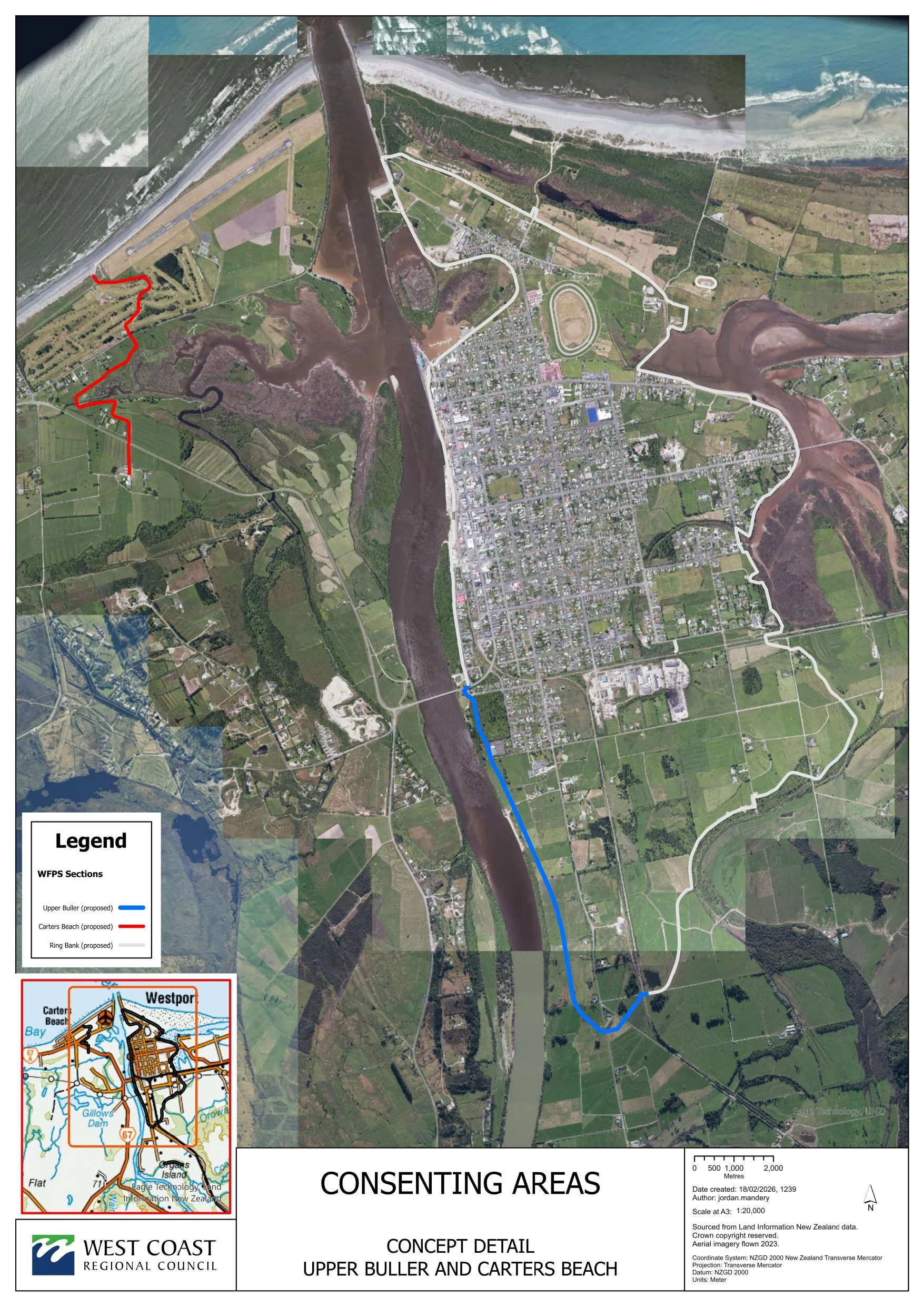
Upper Buller

The scheme is divided into five main sections of stopbanks:
Lower Orowaiti, Upper Orowaiti, North End, Lower Buller (Wharf to Buller Bridge) and Upper Buller (SH67 from Buller Bridge to Nine Mile Road).
The Upper Buller stopbank dimensions:
Length: 2,800m
Height: Varies between 1.5 to 2.2m (depending on ground conditions)
Width at base: 18m
Width at crest: 4m
Earthen stopbank
Estimated construction dates: Starting mid 2026*
*subject to consenting
Upper Buller
The Upper Buller stopbank will be an earthen structure of around 2.8km.
Completed: preliminary design, river modelling, site investigation and geotechnical reporting, initial design and review, Assessment of Environmental Effects, detailed design, Resource Consent application lodged (February 2026).
Current status: A combined Resource Consent Application for the Carters Beach and Upper Buller stopbanks was lodged on 20 February 2026.
Engagement with affected landowners including O’Conor Home, and negotiation of land access agreements is ongoing as is engagement with NZTA (around any potential impacts on the Buller Bridge).
WSP Ltd has investigated potentially removing the historic previous bridge left abutment, as it obstructs flow. This option has been included in the Resource Consent application. We are consulting with the Buller District Council and Heritage NZ around this removal.
Affected parties, including landowners/occupiers, where the proposed flood walls are planned to cross their property or near to it, will be contacted to discuss the proposed work. We are also discussing provisions for specific protection with a property owner near the Upper Buller stopbank.
The Upper Buller stopbank is going to be around 2.8 kilometres long. It intersects private land, as well as the Westport Domain - a reserve managed by Buller District Council.
Estimated construction dates: Starting mid 2026 (subject to consenting)
Joint Resource Consent Application for Carters Beach and Upper Buller stopbanks
The resource consent application lodged with the West Coast Regional Council (WCRC) and Buller District Council (BDC) is for the construction of the Upper Buller and Carters Beach stopbanks, the possible removal of a redundant State Highway 67A road alignment, and the construction of a bund around the Westport Domain.
The Upper Buller consent application has been combined with Carters beach due to the interconnectedness of the two planned stopbanks.
The completed Upper Buller stopbank (up-river from the Buller Bridge) will unfortunately increases the flooding risk for Carters Beach, on the opposite bank downstream.
Upper Buller is part of the ring protection to help protect the Westport township from severe flooding,
The planned work aims to protect Carters Beach from this and mitigate the current flood risk for Carters Beach from major floods.
Once consent is granted, there will be a tendering process for the work.
The Upper Buller stopbank will be around 2.8 kilometres long and take about six months to construct.