

FLOOD PROTECTION

Flood Protection centres on building floodwalls and stopbanks with the aim of protecting Westport in the event of significant future flooding events.
The scheme is divided into five main stopbanks:
Lower Orowaiti, Upper Orowaiti, North End, Lower Buller (Wharf to Buller Bridge) and Upper Buller (SH67 from Buller Bridge to Nine Mile Road).
Within that, there are approximately 20 sub-sections of flood protection including smaller banks like Cats Creek, McKennas, portable barriers, and the Floating Lagoon stopbank.
This is the largest project being undertaken by Resilient Westport and is being led by West Coast Regional Council (WCRC).
The overall aim is to deliver structural mitigation works to prevent direct threats from both the Buller and Orowaiti rivers. These are caused by flooding generated upstream in the Buller catchment and from coastal inundation, particularly via the Orowaiti Lagoon.
The project is funded via a contribution of $15.6m from central government, along with a local share of $10.2 million. Additional funding is now required and WCRC is planning to consult with the community over the shortfall.
The current plan involves a combination of earth stopbanks, ‘planter-box’ stopbanks, concrete floodwalls, wooden floodwalls, and portable flood barriers. The total length will be around 16km.
In 2026, a review of the Westport Flood Protection Scheme (WFPS) has been carried out, after it became clear that there were affordabilty issues.
You can read more on this below.
Project Review
Westport Flood Protection Scheme reset
The development of the Westport Flood Protection Scheme (WFPS) is at the point where changes are required to deliver it in a more affordable way.
This means considering:
The impact on rates arising from the increased cost of the scheme
Changes to the level of flood protection to be delivered for Westport
Funding flood protection for Carters Beach.
The costs of the original scheme are now predicted to reach about $70 million, so the project team has worked on ways to reduce that and still deliver a more credible scheme.
One tool for doing so is to lower the level of protection to Westport to protect against an approximately 1 in 67-year flood (similar to July 2021) – as opposed to 1 in 100-year previously proposed. The level of freeboard (extra height allowance for uncertainty) would also be reduced from 600mm to 400mm following enhanced computer modelling.
The project reset has financial implications for ratepayers and represents additional debt for WCRC. These proposed changes represent a significant variation from what is included in the West Coast Regional Council’s current Long-Term Plan (2024-2034) and what was consulted on with the community in 2021. Therefore, additional consultation is required using a Special Consultative Procedure.
You can read more on this on our dedicated Special Consultative Procedure web page.
We frequently hear certain questions about the scheme and hope these FAQs can shed some light:
When did the project team get started?
The Resilient Westport Flood Protection Scheme has effectively been operating for around 2 and a half years (since early 2024).
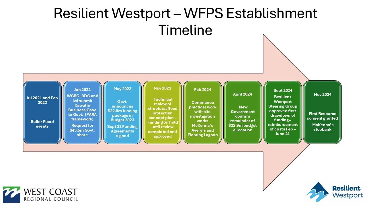
What was the project establishment timeline?
After the floods of 2021 and 2022, a business case was put to government to co-fund flood resilience for Westport.
In May 2023, government announced a $22.9 million funding package (Resilient Westport). In September 2023, the Department of Internal Affairs approved the $15.6 million funding for flood protection.
A technical review of the structural concept for the scheme was carried out between November 2023 and February 2024.
After this, real work began on scoping out the flood protection project.
You can also read more FAQs on the project.
See the timeline below for more:

Planned overall construction programme
The map below identifies the components of the substantive flood protection programme.
Note, the lines shown are indicative only. Where planned stopbanks cross, or are near to, private or public land, property owners will be contacted directly. We do this when we are carrying out investigative work and again as we get closer to final design and consent applications.
You can also download a pdf of this map here.
What consents are still pending?
Floating Lagoon stopbank (adjacent to North End) – Consent lodged in March 2026.
The joint consent application for Upper Buller (SH67 from Buller Bridge to Nine Mile Road) and Carters Beach was lodged in Febuary 2026. It is a combined consent due to their interdependencies. The consent is pending.
O’Conor Home rockwall
Work on the O’Conor Home rockwall is now complete.
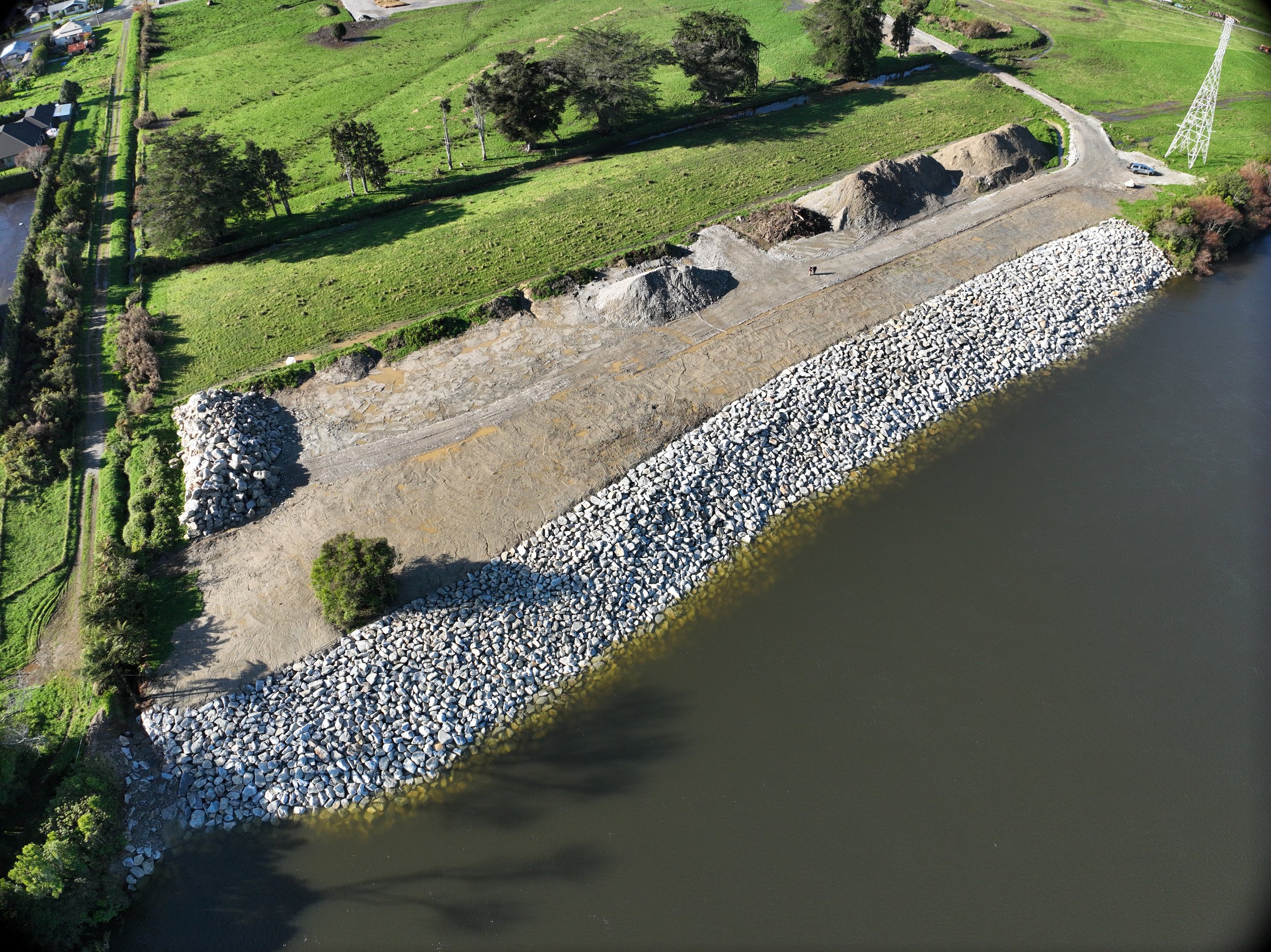
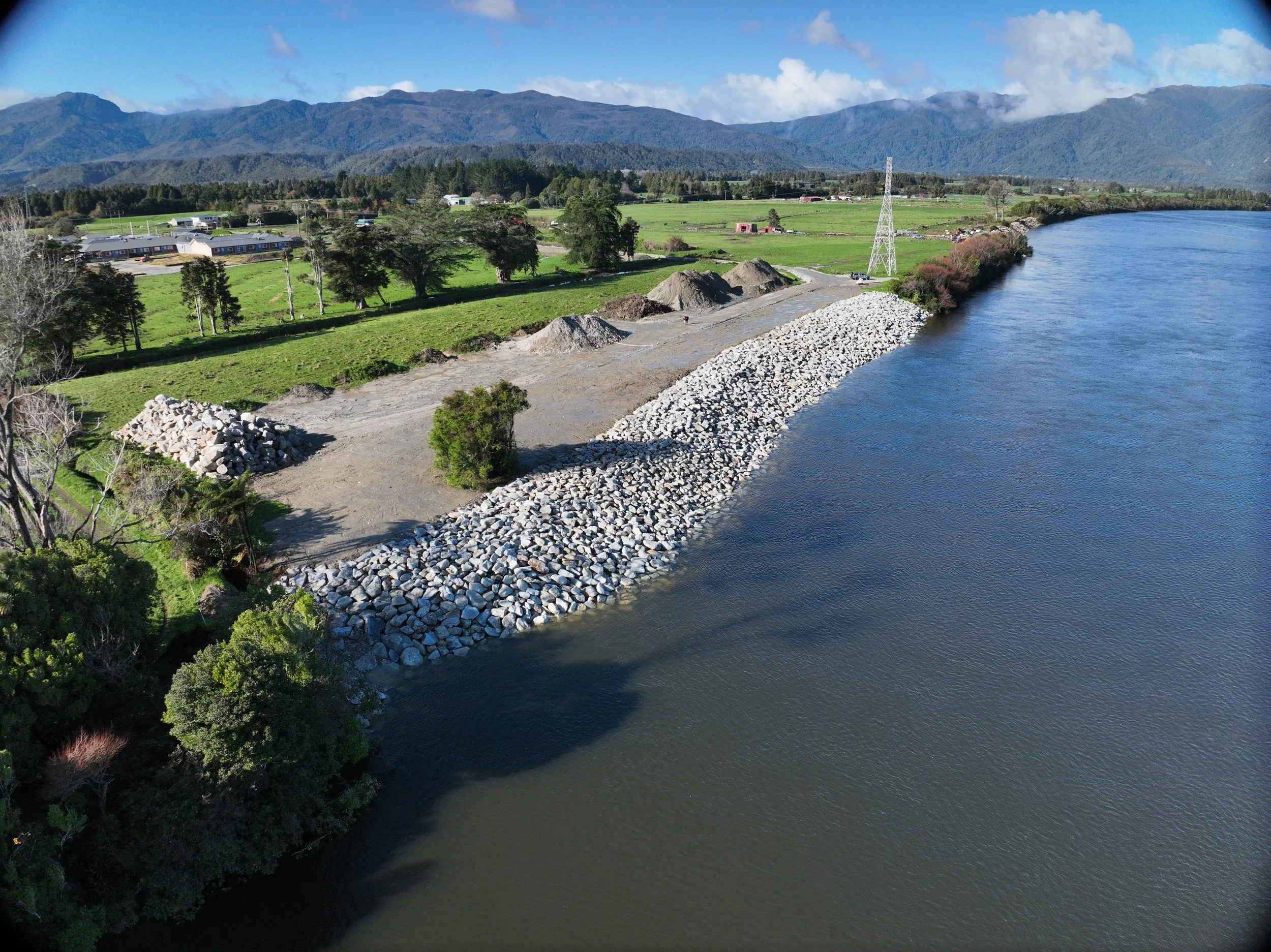
The 170-metre-long rock revetment wall along the Buller River near the O'Conor Home has been built as part of the wider Westport Flood Protection Scheme project.
The rockwall will provide greater security and resilience for the Upper Buller stopbank that is proposed for construction, a short distance inland.
Work began in March, wrapping up this month, in June 2026.
Around 20,000 tonnes of rock have been laid as part of the construction process.
There is some leftover rock that will remain as a stockpile for any future works.

Stage One Projects
The Stage One projects include stopbanks at:
Floating Lagoon (vegetation clearance complete)
Avery’s (consents granted)
Cats Creek (complete)
McKennas (complete)
The Floating Lagoon is a length of land near Westport where a stopbank and 200-metre-long portable flood barriers are planned. It is part of the North end stopbank. Vegetation clearance to allow remediation of the existing stopbank at Floating Lagoon is complete. A Resource Consent application was lodged on Friday (13 March 2026) with West Coast Regional Council (WCRC) and Buller District Council (BDC) for the Floating Lagoon stopbank.
A stopbank on the Avery’s stretch of the Orowaiti River is part of the Lower Orowaiti stopbank. Resource Consent has been granted and a construction date is to be announced.
The Cats Creek bund will redirect floodwaters to the Abattoir Drain. It was completed in late 2024. The bund will assist in reducing inundation of properties downstream of Cats Creek. Following the completion of geotechnical and planning work, physical work was carried out in September/October 2024. The remaining 10 metres, where the bund met with Kiwirail infrastructre was completed in 2026.
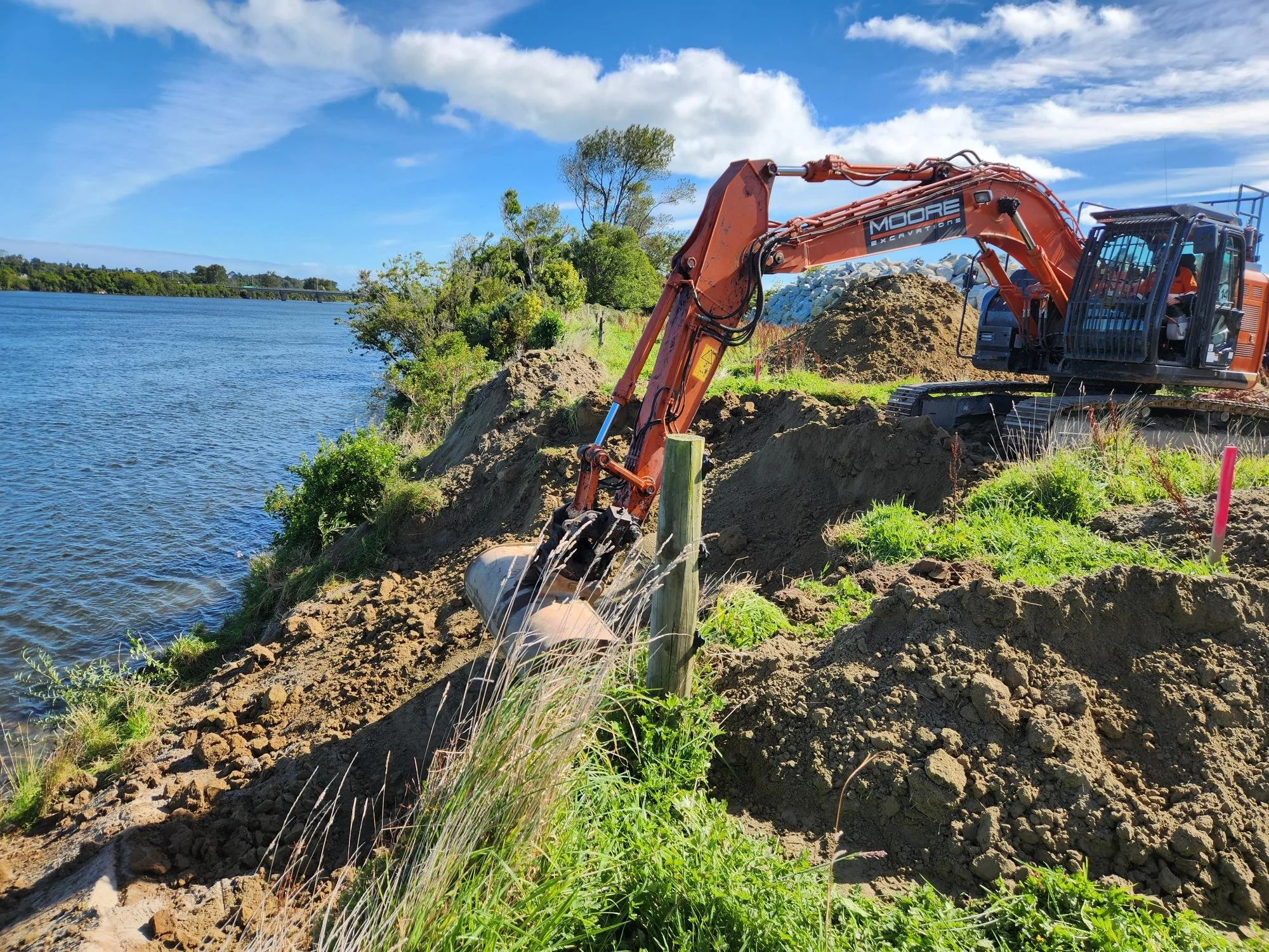
The McKenna stopbank is part of the Upper Orowaiti stopbank and is largely complete A small amount of finishing work is required at the ‘toes’ of the stopbank. A blessing ceremony was held on 18 December 2024 to mark the start of work. A Fact Sheet on the McKenna Stopbank provides information on the work. McKenna is the first of the larger stopbanks to be completed.


West Coast Regional Council Chair (at the time) Peter Haddock, along with Buller Councillor Mark McIntyre (WCRC), and Jo Dooley, on behalf of her late husband Frank Dooley, do the honours celebrating the start of work on McKenna Stopbank.

Organs Island
Orowaiti Overflow/Organs Island is the Buller River’s first overflow location. In the July 2021 flooding event, it overflowed into the Orowaiti Estuary and from there into parts of Westport.
The Orowaiti overflow is the original path of the Buller River and is where it naturally wants to go. It is called the ‘relic river channel’ and is the natural fall of the land.
This land has been vested with West Coast Regional Council for the purpose of flood protection. It was previously administered by Land Information NZ (LINZ) and leased for grazing. It was then transferred from LINZ to Department of Conservation (DOC). DOC then vested Organs Island as a local purpose (flood protection) reserve for West Coast Regional Council to manage as an administering body.
At the 16 December 2025 Operations Committee Meeting, Council approved accepting the vesting to itself (WCRC) as an administrative body.
WCRC has now taken over the management of the land (as at February 2026).
A flood protection options report is being prepared to understand the requirements and costs. Council will then consider the plan for Organs Island.
A rock-training wall was rebuilt by WCRC at Organs Island after the floods and one option is further reinforcing it in some way. The option of revegetating Organs Island may fall to the WCRC at some point in the future, as this is not government funded.
Background
When it was originally diverted in the early 1890s the engineer wrote detailed notes that Organs Island area should be heavily vegetated. He suggested using blackberries and willows because they have strong root density and grow into dense vegetation. Vegetation traps water and sediment/silt and slows flood water. Over time, the land rises and self-seeding occurs. This is a clever, natural flood mitigation technique.
However, the land was gradually cleared and used for farming, weakening the original intent for Organs Island to work as a natural flood mitigant.
Modelling suggests revegetation would reduce water flowing down to the Orowaiti estuary by 10% in a large flood. It will also require less maintenance overtime, reducing costs for West Coast Regional Council.
Your Questions Answered
-
Read more FAQs on the Westport Flood Protection Scheme
-
The stages of a construction project
Concept Design
A line on the map showing the proposed alignment, an initial cross-section, and early cost estimates – this was what was prepared for the business case.
Preliminary Design
Geotechnical investigations and detailed site investigations are done with bore holes drilled, a 3D civil model developed, survey works completed, and preliminary volumes calculated. A preliminary set of drawings is prepared. These drawings require a peer review before moving to the next phase. Documentation of the existing environment and key values is completed. Safety in Design is considered, and options are assessed.
Detailed Design
Early Contractor Involvement (ECI) is used to help understand temporary works requirements
Geotechnical analysis completed, including seepage. Full design of all elements, including a full set of drawings, a schedule of quantities, and specifications covering all services such as utilities.
A detailed design report is prepared, including the final assessment of effects.
Feedback is gathered from affected parties, including iwi, ecology specialists, and landowners.
Peer reviews are completed for seepage analysis and stability, and civil engineering is peer reviewed by WCRC.
Safety in Design is confirmed. A contamination remediation action plan or long-term site management plan is developed if required.
Final Design
Feedback from the consenting process and engineering approvals is incorporated. Changes from the detailed design stage are typically minimal. Final drawings, schedules, specifications, and contract documentation are prepared to support construction.
-
It’s all about the planning!
Sometimes we are asked why this all takes so long. Here’s a bit of a snapshot of what goes on long before any spade hits the ground. There’s:
Initial concept design
Flood modelling
Land owner negotiations for access
Geotechnical and groundwater studies (what is the land like essentially)
Assessment of environmental effects
Geotechnical design
Production of tender documents and drawings
Lodging and gaining consent
Tendering
And finally construction.
-
Most of the structures will be earthen stopbanks, constructed by compacting layer upon layer of gravel, then covering the stopbank in topsoil and planting grass or vegetation. This may vary and will be shared when the final design is complete for each section.
The current plan for the whole flood mitigation project involves a combination of earth stopbanks, ‘planter-box’ stopbanks, concrete floodwalls, wooden floodwalls, and portable flood barriers.
-
Westport's stormwater and wastewater network, like those in many towns and cities throughout New Zealand, suffers from aging and under-invested infrastructure. Significant upgrades may be required to ensure functionality and resilience in the future.
Westport’s small population and rating base is a significant challenge for further network improvements and work is widely dependant on external funding.
Buller District Council (BDC) is working on ways to improve this and integrate improvements with the planned new floodwalls.
BDC is currently completing stormwater network modelling, which together with an improved understanding of the current stormwater infrastructure will help identify the scope of work required. The integrated stormwater will provide a range of design options and costings, including affordability considerations. The concept study will be completed mid-August 2024, which will then guide and inform next steps, including application for further government funding support due to the affordability challenges.
Alongside stormwater network upgrades another key long-term objective is network separation (separating stormwater from wastewater) and wastewater modelling to establish how to optimise the performance of the stormwater and wastewater systems.
A report by Worley's presented to Council in late 2024 provides options for creating a flexible and cost-effective stormwater management system to reduce flooding in Westport during both routine and extreme weather events. This includes using high-capacity and mobile pumps, as well as nature based solutions such as rain gardens and detention basins.
Further modelling is required before decisions can be made about actioning the suggestions made in the report. A Regional Infrastructure Fund applicaiton has been made meanwhile to secure possible funding.
Buller Flood Recovery and subsequent work
Efforts to improve the stormwater system have been undertaken in the immediate wake of the floods.
As part of the post-flood essential infrastructure repairs, National Emergency Management Agency (NEMA) funded the lifting of four wastewater pumpstation electrical cabinets to above 1 in 100 year flood height. These were: North Beach pumpstation, Derby Street pumpstation, Rintoul Street and Roebuck Street pumpstation.
It is hoped that more pumpstations can be lifted in the future. This work will be prioritised based on flood risk and in conjunction with long term pumpstation renewal schedules.
Nineteen WaStop® valves have also been installed at key stormwater outfalls throughout the Westport township. The valves provide more network resilience and are better able to protect against floodwater infiltration (backflow) at many key stormwater outfalls.
Crown Infrastructure partners Better Off funding covered the cost of supplying and installing 14 of these WaStop® devices. Another 5 were installed with funding from National Emergency Management Agency (NEMA) as part of the post-flood essential infrastructure repairs.
-
ARI stands for annual recurrence interval which is sometimes also known as ‘return period’. It is the average time period between floods of a certain size. For example, a 50 year ARI event would on average happen every 50 years.
-
AEP stands for annual exceedance probability (AEP) which is the probability of an event occurring in any given year.
So a 1% AEP means there is a 1% chance in of the event occurring in any given year of the event occurring. This means that on average 1 event of this size will occur every 100 years. Therefore, 1% AEP is equal to a 100 year ARI, a 2% AEP is a 50 year ARI, and a 10% AEP is a 10 year ARI. Both ARI and AEP values are based on statistical calculations and represent the average timing of events.
-
RCP stands for Representative Concentration Pathways (RCP). These are climate change scenarios to project future greenhouse gas concentrations.
These pathways (or trajectories) describe future greenhouse gas concentrations (not emissions) and have been formally adopted by the Intergovernmental Panel on Climate Change (IPCC).
The pathways describe different climate change scenarios, all of which were considered possible depending on the amount of greenhouse gases (GHG) emitted in the years to come.
-
RCP 4.5 is described by IPCC as a moderate scenario in which emissions peak around 2040 and then decline. RCP 8.5 is the highest baseline emissions scenario (essentially business as usual) in which emissions continue to rise throughout the twenty-first century. In the Westport context, RCP 6 is applied in terms of climate modelling, which reflects some stabilisation of climate emissions. This is based on NIWA advice.
-
Freeboard is engineering provision for estimate accuracy and other factors not included (waves, aggradation, debris etc). Freeboard is a safety feature that provides storage capacity and prevents spills.
The definition of freeboard is presented in Section 1.2.2 Definitions of New Zealand Standard NZS 4404:2010 Land Development and Subdivision Infrastructure. That states:
A provision for flood level design estimate imprecision, construction tolerance, and natural phenomenon (such as waves, debris, aggradations, channel transition, and bend effects) not explicitly in the calculations.
You may ALSO be interested in:
Media Release: Resource consent granted for Averys stopbank in Westport
Media Release: Resource consent application lodged for Westport’s Floating Lagoon stopbank
Media Release: Joint resource consent application to be lodged for Carters Beach and Upper Buller stopbanks
Media Release: Drill rig to be spotted around Westport
Media Release: Work on McKenna stopbank wraps up